SPOREKRANS HIKING TRAIL |
|
Ó Copyright: G du Preez |
|
| Please scroll down
to see the pictures... The
place...
Bergdeel Private Nature reserve between Bethlehem and Fouriesburg in the Eastern Free State. The date... 3-5 April 2004 The hikers... The Du Preez's from Bloemfontein: Grobler, Marlene and Ignatius . The trail ... This trail is classified as easy - probably true if you are young or very fit or without backpacks. We experienced it as difficult because we were not fit at all. Do not underestimate this trail. If you are afraid of heights, the hike can become a nightmare - the trail ascends immediately to above the cliffs and stays there for many km's. Wooden ladders takes one down into a gorge - very, very scary if you are afraid of heights. Hikers stay over the night before in the base camp at the start of the trail. Hot showers, electric kettles, fridges and a hot plate/gas stove makes the stay pleasant. Fire wood and a braai grid is supplied. The overnight cave is a sandstone overhang with 34 log beds with mattresses. Fire wood, "driebeenpot", kettle and a braai grid is supplied. Water is supplied and is also available on the trail during a good rain season. Day 0: The journey to Bergdeel (2004/04/03) We departed at 13:00 from Bloemfontein to Bergdeel via Ladybrand, Ficksburg and Fouriesburg. Arrived at 15:15. After "braaivleis" it's off to bed. Day 1: Base Camp to Bushmen's Cave (2004/04/04) 12 km Breakfast and then off we go at 07:45. Over a wooden bridge and wooden ladder then up in "Stinkhoutkloof" through dense bush to a small plateau above the cliffs. From here the trail proceeds along the cliffs for several km's and then tries to maintain a contour line against a mountain. A herd of Eland grazed far below us. We arrived at " Kudu Poort" at 09:55. "Tea Time Tree" provided a welcome break at 10:45. Shortly before the trail started to descend to the valley below, big herds of Eland, Blue Wildebeest, Blesbuck as well as a few Kudu's came into view. The trail now descends into the valley back in the direction of the base camp until Bamboo Gorge comes into view. "Hier gaan ek nie af nie!", the youngest member of the gang exclaimed. A wooden ladder disappeared into the narrow gorge below. Eventually we started down the scary ladder (more of a tilted bridge than a ladder - about 20m down at a 45-70 degree angle), turn 90 degrees and down again a few metres, then onto a wooden bridge without rails, then 8m down another ladder and across two bridges, all very scary for someone with a fear of heights. After approximately 6 ladders and 12 bridges, we reached the Mermaid pools where we crossed the last bridge. From here the trail markers are very confusing. The marker points back into the direction from where we came, but the trail disappears into the grass with the next marker not visible. After a lot of climbing up and down looking for the trail, we decided to rest and eat lunch. We eventually discovered a marker high above us against the cliff. On our way to the marker, we saw a marker lower down and took shortcut to it. The next stop was at the "sporekrans", a sandstone cliff with markings looking like footprints - from here the name of the trail - footprints= spore and cliff = krans. At this point, a marker shows that the overnight cave is only 200m away. We quickly realised that it would be a long 200m - the trail ascends the hill towards the Bushmen's Cave high above. We eventually reached the cave at 15:45 after many stops and the help of a little "dynamite". It is a huge, but very dusty sandstone overhang. Water is supplied with a tap fed from a stream above the cave. A loo "with a view" is a short distance from the cave. We started a fire and roasted bacon on the coals. We complimented it with dried vegetables and sweet potatoes cooked on our gas stove and concluded the meal with instant custard and condensed milk. The lights were turned off at 19:00 (but nobody wanted to close the windows). The cave (sandstone overhang) is only a few metres below the morning's trail - we have been walking over it several hours before. It is also only a few hundred metres from the base camp - no real need to sleep in it except for the experience. Day 2: Bushmen's Cave to Base Camp (2004/04/05) 4.5 km Breakfast and then off at 08:55. I would recommend returning directly to the base camp to dump the backpacks before continuing with the trail - remember to take water with you on the trail. The trail crosses the stream a short distance from the Sporekrans and stays parallel to it until another stream crosses it's path. At this point, a bull showed clearly that he was unhappy with my presence - I quickly took a detour. No trail marker was in view and I had to read the map. According to my interpretation of the map, the trail at this point turned 90 degrees to the right, which means that the trail follows the stream entering from the right-hand side. After a very exhausting, mud wrestling hour in a narrow gorge, a broken wooden ladder came into view. Was this Donga Bridge? The nature reserve border was in sight so I had to get out of the gorge. I clambered out against the muddy slopes and ascended to the top of the plateau. I started walking back towards the base camp and eventually came upon a trail marker - showing clearly that I was completely lost. I continued directly towards the base camp. A hot shower at the base camp, a cup of coffee and off to Golden Gate for the next part of our adventure- the short trails at Golden Gate and the Sentinel trail with it's chain ladders to the top of the Amphitheatre. Conclusion This was the first time I completely got lost on any trail - twice on the same trail. After good rains the footpath becomes less visible and trail markers are hidden in the grass. Trail management should ensure that the next marker is always visible from the current marker and should provide a trail map showing the contour lines. |
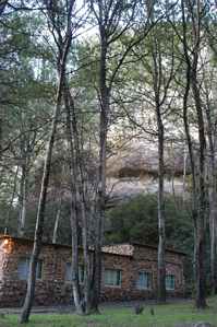
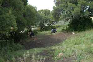
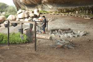
DAY 0: The Base Camp
The night before the hike is spent in a comfortable hut
nestled between trees against a sandstone cliff.
DAY 0: Caracal's ladder
Departed 07:45. The trail ascends the sandstone hill via "Stinkhout Kloof". We arrived at Caracal's Ladder in "Stinkhout Kloof" at 08:30. ('2' on the map)
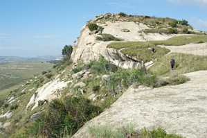
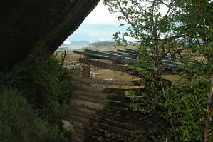
DAY 0: Angel Heights
The view towards Angel Heights as seen from the top of Stinkhout Kloof. Arrived at this point at 08:50.
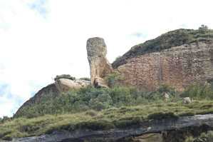
DAY 1: God's Little Finger
If you walk next to the fence to stay as far as possible from the cliff, you will not see it. This picture was taken from below the cliffs on the direct route from "Sporekrans" to the base camp.
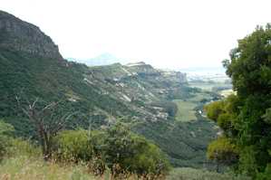
DAY 0: The view from "Tea Time Tree"
Angel Heights is visible as the highest point in the middle of the picture. The overnight cave and Sporekrans is also visible if you know where to look
DAY 1: Tea Time Tree
A shady rest and a snack at 10:45.
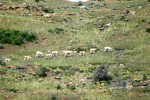
DAY 1: Eland and Blesbuck
Eland, Blesbuck, Wildebeest and Kudu could be seen against the slopes. This picture was taken from 'A' on the map.
DAY 1: Bamboeskloof (Bamboo Gorge)
A wooden ladder (visible middle right) disappeared into the narrow gorge below.
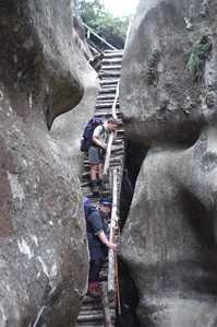
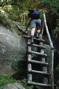
DAY 1: Scary ladders
Marlene and Ignatius on the third ladder. The first ladder is visible at the top (more of a tilted bridge than a ladder - about 20m down at a 45-70 degree angle).
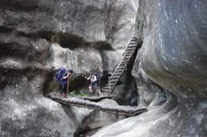
DAY 1: 3rd ladder, 2nd & 3rd bridges

DAY 1: Another ladder - part 2 of a set
The first part of this ladder is directly on top of this one, descending from right to left.
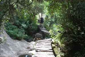
DAY 1: More bridges
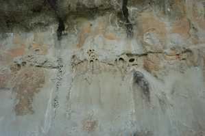
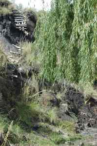
DAY 1: Sporekrans
The markings on the sandstone overhang resembles those of animal footprints..
DAY 1: Bushmen's cave
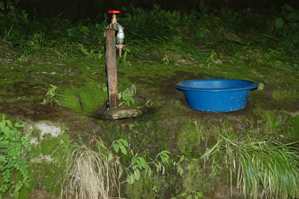
DAY 1: Tap water in the cave
Water is supplied with a tap fed from a stream above the cave.
DAY 1: Loo with a view
This long-drop is a short distance from the cave.
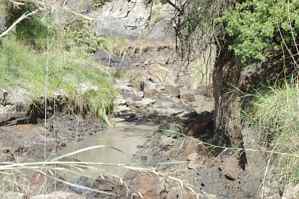
DAY 2: Mud wrestling
Is this the correct route or am I lost?
DAY 2: Is this Donga bridge?
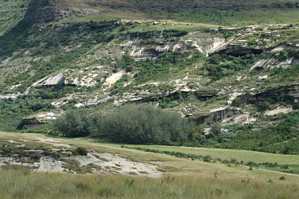
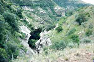
DAY 2: Bushmen's Cave & Sporekrans
Bushmen's Cave is near the top on the right-hand side and Sporekrans on the left, one-third from the bottom. Bushman Baths (5 on the map) is on the plateau on top of the cave. This picture was taken from 'B' on the map.